Above three pics at low tide today, right bottom is blackhead.. getting chewed out even more.. Below, article in yesterdays ODT:
Below article from the ODT July 28th.
some more shots of the constantly moving sandcastles below.

super low tide with new moon.. back to the rock bottom for St Clair (excuse the pun).

Labels:
Sand Mining
comments (0)
Erosion all down the coastline, this one about Kuri Bush way, I am sure this will effect the sand mining consent given earlier this year for Kuri Bush, as I believe under the consent the beaches need to be monitored for any adverse effects, so with most of the sand being stripped it would limit their operations? Check my report on it here: 'Sand Mining Given Go Ahead'
Also the Erosion at Tomahawk beach in the corner where a current Sand Mining consent is running would be extremely effected as most of that was washed out a week back.

Above, a view from the end of the Hot Saltwater Pool, this time with key areas labeled to give a more detailed overview of what is where, also providing some scale and perspective.
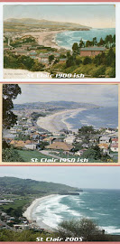
Above: Comparisons 27th march 2007 & 4th August 2007.
Below: Today, countless more truckloads of sand have been deposited over the dune at the end of the access way from The Marae at 2/3rds.
After reporting on 4th August's massive hunk out of Middle beach over the last week, I made it down to the sports fields to take some images from the top. The erosion is now well into the downward side of the dune and would be only metres away from the edge of the sports ground.


Above right: the dumped sand from the harbour over the edge of Moana Rua Road continues to slump and fall to the beach below to be washed away.
Above: Looking towards St Clair with Moana Rua Road a few Metres at my back.
Below:The mixture of sand and rock reinstated at the base of the sausage buffer see here has been reduced to a pile of rocks.


Above left: again the rocks remains, right: forgot to put up from the 4th, a view from the Hot Saltwater Pool.
St Clair / Kilda now a new left Point break?
A natural process of beach recovery after storm erosion events have gouged out the dunes and flattened the beach profile is for large sand banks to form 200metres out to sea. This is to dissipate the wave action coming in towards the dunes, so that less energy impacts upon the beach and dunes. This allows the barrage of wave action to be minimised so the beach can themn begin to recover.
During this easterly swell, the banks created some long peeling surfable waves, much like a point break.
This morning revealed another 3-4 metres of dunes washed away into the sea with a rather bizarre water course ditch forming parallel to the dunes at the base.
Another forceful South East swell due to hit tomorrow, I just can't even find words to describe the anguish I am feeling .. just watching it all happen. In all my research of the history of this area, there has never been such severe erosion as what is occuring now. Its all too little too late. Yes it's the uncontrollable force of nature. Well intended decisions have been made in the past with regards to planning, engineering and beach protection initiatives. We can see now that none of these measures have proven to be sustainable. But now there is absolutely no excuse not to implement a long term viable solution to this most urgent issue. Bugger the cost! Stuff the Otago Regional Council (front page todays ODT) earmarking 12 million for new offices on the waterfront because they're a little cramped.. and 10 million dollars for a feasability study for a rugby stadium?? Priorities??
Below: comparison left is today, right is 4th May 2006
half a million or so spent earlier in July trucking in sand to cover the slashed sausages for emergency protection work, now a month later nearly 2 thirds of the sand has been washed away, again exposing parts of the sausages..

2 Above: today digger creating yet another rock and sand buffer at the base of the washed away sand placed over the sausages last month.
2 Below: looking towards Middles today showing the loss of the sand buffer over the sausies, pink circle showing one exposed.

Below left: 31st July taken from the top of Moana Rua Rd looking down showing the rubble 'buffer line' created at the toe of the eroded dune.. right: 5 days later with increased erosion and exposure of rubble at the base


Above right: More exposed rubble, which I thought they were removing?
Above left: the new trench which has formed at the base of the dunes at middles/kettle park side (low tide).
Below left: Today at low tide, waves peel off a second bank parallel to Middle beach creating a long peeling left, and that wasn't even a set coming through. Right: a closer look today.

A quick pop down to see how the half million dollar sand buffer was holding up..
there was quite a chunk out.. and a steep scarp which a digger was smoothing off.