Save Ocean Beach

The natural and physical resources of Ocean beach and its adjacent City Dunedin are under threat and you can help!

Sand levels have remained constant and high throughout December. During the last two weeks of December, regular south-westerly winds resulted in a slight reduction in the sand levels at the salt water pool end of the seawall, re-exposing some rocks, but the same winds have also resulted in an increase in the sand deposits at Lawyers Head. At the time of writing of this report, the sand bar, usually just off shore, had moved landward creating a very wide, flat beach at low tide.

Access to the beach remains available at all points, however access via the accessibility ramp might be difficult due to a slight drop at the bottom. Sand levels on the beach continue to be monitored regularly.

Ocean Beach has continued to remain popular with New Zealand Sea Lions and even Leopard Seals. Please keep an eye out for advisory signs (with an outline of recommended behaviour around these animals) that are now in place.

From the ODT By Chris Morris on Mon, 7 Dec 2009

Submissions must be received by the Dunedin City Council
before 5pm Friday 12 March 2010'
Members of the public have until mid-January to have their say on a new management plan for coastal reserves around Dunedin.

Dunedin City Council staff have identified 11 coastal reserves across the city - including at Brighton, Karitane, Long Beach, Ocean View, Waikouaiti and Warrington - to be reclassified under the council's draft coastal dune reserve management plan.

The change would result in the reserves' status being changed from recreational areas to local purpose (coastal protection) zones, providing new powers to protect the sensitive areas at the expense of some recreational rights.

Councillors at a recent meeting of the community development committee voted to approve the draft management plan, containing the reclass-ifications, for a two-month period of public consultation.

Depending on the number of submissions received, a public hearing could follow.

A report to the meeting by council reserves policy and planning officer Dolina Lee said the change aimed to protect and preserve the dunes while providing for recreation where possible.

Under the Reserves Act 1977, local authorities were required to classify the primary use of the reserves they owned.

Speaking to the Otago Daily Times earlier this year, council community and recreation services manager Mick Reece said changes in the reserves' status recognised the importance of protecting the coastal environment from flooding, erosion and other threats.

"You can't recreate if the dunes disappear and you are inundated, so the primary driver for managing the reserves should be coastal protection," he said.

Consultation was the latest step in the development of the draft plan, stretching back to 2002.

Approval of the reclass-ifications was needed by the Department of Conservation, and a final approval of the changes would be made at a subsequent council meeting.

Sand levels have recovered well, and at the time of writing this update, access to the beach is available at all points. Sand levels on the beach are being monitored regularly, and will be augmented on an "as required" basis over the summer.

Ocean Beach is also proving popular with New Zealand Sea Lions, and a number of these animals are frequenting the beach from time to time. Advisory signs (with an outline of recommended behaviour around sea lions) are now in place.

The generally high beach profile (the level of sand) on Ocean Beach continues. The track from the Esplanade end has been re-opened, and the steps to the beach have been reinstated. While there has been some sand loss, a good deal of the very healthy reserves of sand remained until recently.

The Project Team is reviewing the information that is being gathered as background for the Long Term Management Plan, and the program for completing the studies and preparing the Plan remains on track. The maintenance regime will continue as the information gathering process draws to a close.

The sand loss on Ocean Beach over winter months (July especially) has now been largely recovered. In the interim, the damage to the Reno mattresses (that provides protection to the toe of the dune at Middle Beach) was repaired, as was damage to that section of the rubble wall that had been uncovered. The repaired Reno mattresses and the reinstated rubble wall have been re-covered by sand, and the remaining machinery has now been removed from the beach.

Monitoring of sand levels will go on, and the maintenance regime will also continue on an 'as required' basis as the information gathering process concludes. The Project Team appointed to draft the Long Term Management Plan is now meeting on a regular basis, while the program for completing the studies of the beach, adjacent off shore environment, as well as the eventual preparation of the Plan itself, remains on track.


St Clair surfers would have noticed an incredible increase in the volume of sand being deposited at the base of the sea wall, and out into the break its self. I have heard it described at the beginning of the week as pipeline-like. below: a view the new Hotel on the Esplanade with sand build up. And the 6 dogs on the beach where Dogs are prohibited on St Clair Beach.
Pic at Bottom: Harbour dredging's have been deposited on the wharf the last few weeks and trucked to Moana Rua Rd where massive amounts have been dumped off the end to build up the toe of the dunes. This spoil has then immediately been washed into St Clair with the east swells. You can see the scarp at the base of fill.

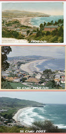
Nature's way may be Middle Beach answer

ODT Thu, 27 Aug 2009

The initial response to coastal erosion is often the construction of a sea wall, but Phillip Cole argues that will not do the job at Middle Beach. He advocates a policy of "managed retreat" instead.

Pictures and stories last month serve as a timely reminder to those who will decide the fate of Middle Beach when the project team discusses the initial results from the year-long gathering of data in September.

In an Otago Daily Times front-page report six months ago, the Dunedin City Council reiterated that it would be looking at a range of "hard" and "soft" options for Middle Beach and that it would not be ruling anything in or out in coming to a solution.

The different types of solutions will have their own sets of unique problems and financial costs, a fact acknowledged by the council. The time scale of several years before any construction can take place, however, is the most telling feature of all.

So where does that leave the Middle Beach problem? The stadium costs and other major project spends will leave the council with very little money for this project.

The council has stated that $400,000 over the next three years has been set aside to deal with the problems (already depleted by at least $60,000 due to the recent events) but, rather alarmingly, no money has been set aside for a long-term management plan, or indeed for the four years until "any construction can take place".

By default, then, the council may have to consider the option that wasn't mentioned in either story but was raised at the submissions hearing - that of a "managed retreat".

  • Often, the initial response to shoreline erosion is to build a sea wall.
  • A sea wall will not solve the problem at Middle Beach.
  • Sea walls force waves back to the ocean.
  • These waves take the sand in front of the sea wall and deposit it far away from land.
  • The water in front of the sea wall gets deeper and makes for bigger waves next to the shoreline, so you always have to build larger sea walls.
  • The sea will always win this battle, because the force of water will always be stronger than any sea wall.
  • Adopting a managed retreat policy at Middle Beach will be successful if it begins at a grassroots level.

An open and honest approach will have a successful outcome, as it will involve all major players in the planning process and address their concerns.

Although the process will take time, a consensus can be reached that will enable a managed retreat to be the best alternative to solving the long-term problems of Middle Beach.

Indeed, this could take place in the "several years" before any construction takes place, as quoted in the newspaper report.

One could argue that consultation at a local level could have already begun since the submission hearings in April 2008 to hear and consider the views of the people that will ultimately be affected by whatever action the council decides upon.

A golden opportunity presents itself to the council here.

An integrated planning strategy can be developed where people affected by the erosion can be relocated into new sustainable housing developments where they would no longer be affected by the current sewage, drainage and flooding problems that will continually arise whenever there is a downpour in South Dunedin.

Property owners who would be affected could have compensation paid at market rates for their properties, or "swap" their current homes for new ones built to replace them.

Managed retreat, in the case of Middle Beach, is an important soft engineering coastal defence technique which aims to achieve sustainable flood defence by creating new defences further inland and allowing the land behind the existing sand dunes to be flooded by the incoming tide.

The existing coastal defence, in this case the sand dunes, would be breached, allowing the land to be tidally inundated and colonised over time by salt marsh vegetation. When established, the vegetation disperses wave energy during storms, reduces erosion rates and provides an important habitat for coastal flora and fauna. A new embankment is usually constructed beforehand on the landward side of the site to reduce the risk of flooding.

It is widely recognised that managed retreat of a shoreline can reduce the costs of coastal defence while offering numerous environmental benefits. Managed or "planned" retreat allows the shoreline to advance inward unimpeded. As the shore erodes, buildings and other infrastructure are either demolished or relocated inland. In many situations attempting to stop erosion through structural or non-structural solutions is a losing battle.

Shoreline protection efforts and/or their repeated maintenance would be too costly and ultimately ineffective at preventing further erosion. A managed retreat approach typically involves establishing thresholds to trigger demolition or relocation of structures threatened by erosion. The advantage of a managed retreat system is that it is usually less expensive than costly structural stabilisation projects that may only be a temporary solution, especially in highly erosive areas such as Middle Beach. It also maintains natural shoreline dynamics and enables shoreline habitats to migrate inland.

There are no direct costs, aside from the removal of any defences already in place, and maintenance costs are very low. The inter-tidal region is able to dissipate wave energy and protect property and land, while supporting a wide variety of plants, invertebrates, molluscs, birds and fish. Sediment flow is also restored to its natural state; beaches can be naturally replenished due to erosion of the coast, providing protection and the balance of the coastline returns.

Yes, this method can be politically difficult to implement, particularly where significant development has already occurred. It may cause shorefront property values to fall. With an in-built political and institutional preference for "hard" engineering schemes this solution will face a lot of opposition.

But what came first - the shoreline or the buildings? The future, as we all know, is unknown. Scientists forecast sea level rises, but there are unknowns that could rapidly change their forecasts. Therefore, the traditional approach to design cannot be applied to Middle Beach, simply because historical data is less applicable.

A change in outlook is required by how people plan for such challenges, how the community accepts the change, and crucially, how our council involves the communities to adapt to change. Rising sea levels do not come into the equation, as most of South Dunedin is currently below the present sea level.

The council has an opportunity here to be both forward-looking and bold in its search for a solution to the problem. History has shown that man cannot control nature, especially where sea action is concerned and the council should take this on board when looking for a solution.

As the council parks and reserves team leader Martin Thompson said (ODT, 16.01.2009): "We are at the mercy of the sea, basically, in terms of what sort of storm events we get . . ."

A sobering thought indeed.

The high beach profile (the level of sand) on Ocean Beach for the first half of the year has proved invaluable in recent weeks. While there was some sand loss in the early part of winter, a good deal of the very healthy reserves of sand remained until recently. Much of it was stripped away by the strong winds and high tides experienced during July. With the removal of that sand buffer, a section of the rubble wall has been uncovered and there has also been damage to the Reno mattresses that provided protection to the toe of the dune at Middle Beach. The Reno mattresses are being repaired, the rubble wall reinstated, and sand levels at Middle Beach are being topped up on an 'as required' basis.

That maintenance regime will be continued while the information gathering process draws to a close. A Project Team has been appointed to study the information that is being collated for the Long Term Management Plan, and the program for completing the studies and preparing the Plan remains on track.

Encroachment by heavy seas checked
ODT By Allison Rudd on Mon, 27 Jul 2009

It was estimates $50,000-$60,000 had been spent at Middle beach in the past few days trying to protect rock mattresses laid at the base of the dunes, which had been exposed by last week's heavy seas, and trucking in sand dredged from Otago Harbour and tipping it down the face of the dunes.He estimated the width of the dunes had decreased by 2m-3m in the past two years.The end of Moana Rua Rd fell away last Thursday, and the face of the dunes was now close to a large fence erected in 2007 to stop people from using a dune-top track which has also since succumbed to the sea.

It was difficult to believe the Moana Rua surf club building had once sat between the end of the road and the beach, he said.

"When we demolished that [in 2001] there was a lot of criticism. People said it would have made a good restaurant. But the area it was sitting on does not exist any more."


full ODT article online here By David Loughrey on Sat, 25 Jul 2009
An ODT online poll was also run

From a POLL at the Otago Daily Times Sat, 25 Jul 2009
Below are two comments related to the POLL


I have lived in Tomahawk for 35 years from 1960 to 1995 and lived right across the road from the sandhills. During that time I have seen the line of dunes going down to such an extend that I circulated a petition expressing concern at the excessive sandmining that occurred. (I believe it is still going strong). The Ocean Grove Domain Board members rubbed their hands in glee at the goldmine at their doorstep and took no notice of the petition that was signed by 95% of the residents. When we amalgamated with Dunedin I wrote to the Dunedin City Council expressing my concern at the continuing sandmining and the erosion of the dunes. I received an answer from a Mr Archer who wrote that the Dunedin City Council shared my concern and that something would be done as soon it came under the Council's jurisdiction. In 1995 I left Tomahawk, disappointed with the lack of action as the Dunedin City Council despite their promises, did absolutely nothing. I believe that the erosion at Tomahawk beach is not only caused by nature, it also did have a mighty helping hand by the continuing sandmining over so many years


It really doesn't matter whether it's caused by global warming or not - the fact is that peak high tides are eating away the only protection South Dunedin has between it and the Pacific. And all the we really have there is a pile of sand.

It's not like peak high tides like this are not predictable (hint: all the fuss about solar eclipses is a little related, tide tables are readily available). Let's face it if the sand loss continues for much longer we're going to have to build something like a concrete dike from St Clair to Lawyers Head.

As I've mentioned in this forum before I think this is potentially the most pressing problem the council has before it - it's quite scary to read that they've not budgeted anything for the issue - instead we're blowing our piggy bank on vanity projects like the stadium - any sensible local body should have reserves for just this sort of occurrence or should have anticipated the problem and have planned ahead.

Channel 9 news -

Council Contractors have been working to minimise the effect of erosion on Middle Beach which has occurred because of high tides over the past few days.

Local sports fields at Hancock park are in danger of becoming part of the coastline after the exceptionally high tides and winter swells have undermined sand dunes.

On Wednesday, this pile of rubble was sitting at the base of the dunes, but that pile has been brought forward to create a shock absorber to the force of the waves.

These developments are seen as a temporary measure, as the Council is currently gathering data in order to come up with a long term solution to erosion in the area from St. Clair to St. Kilda beaches.

UPDATE 25th July 2009 article from ODT
"It's as serious as it's been since the emergency [in 2007]."
Contractors next week would build a new mattress and place it behind and beneath the existing ones.


Above: today looking down towards St Clair, below, compare to a series of images over the last 2 years from a similar spot. Although the beach profile is lowered, there does not seem to be such an effect on the St Clair end, with most of the erosion around Moana Rua Road. Also a bit further along where the Tahuna outfall pipe was, has been gouged out more than the rest of the beach .


Above left: pulled back view , right: closer view of the digger work at Moana Rua, where in the last two days they have delivered truckloads of sand over the edge of the road, and replenished sand over the rock mattresses and boulders recently exposed at the base, as seen below:
Two days ago

Above photo taken on Wednesday from the base of Moana Rua Road at Middle Beach, note the scattered boulders on the sand at the base. Also the exposed rock mattresses. Significant lowering of beach profile.
Below left: the digger arrives, and first thing it tasks to is to dig up the scattered boulders on the sand(as seen in pic above)and place them on top of the rock mattresses. They are now all gone. Now, I understand that removing these actually cause more erosion. I was told that this was done at St Clair when they were building the new sea wall. Rocks were removed from the shoreline which caused significant lowering of the beach profile. They are actually needed to retain sand. Any thoughts on this?

Above right: damaged and exposed rock mattresses.
Article "Tides flood roads, erode dunes" at ODT.
Below, today St Clair, a good fill of sand at the base of the sea wall.
Motel progressing well, I think its looking pretty good!


Work is currently underway on Middle beach between St Kilda and St Clair, as erosion is threatening to undermine the sand dunes keeping the sea at bay from South Dunedin.

The issue has been a significant one for the city over the last few years, and is adding pressure to the Dunedin City Council to come up with a long term strategic plan to combat it.

Otago Daily Times
By Chris Morris on Wed, 15 Jul 2009
Eleven of Dunedin's coastal reserves look set to be given new protected status, at the expense of some recreational rights, in an effort to protect vulnerable sand dune systems.

The move would see coastal reserves next to beaches at Long Beach, Ocean View, Warrington and Karitane, and seven other locations, reclassified.Under the Reserves Act 1977, local authorities were required to classify the primary use of the reserves they owned.However, councillors at yesterday's community development committee meeting voted to approve the reclassification of 11 coastal reserves around the city from recreational areas to "local purpose (coastal protection)" zones.

Subject to final approval at the next full council meeting in August, the changes would become part of the council's draft Coastal Dune Reserves Management Plan, due to be released for public consultation in October.The new plan laid out the future rules governing work to protect dunes at Dunedin beaches.


To be protected

• Kuri Beach (two areas on coastal side of Taieri Mouth Rd)
• Brighton (coastal side of Brighton Rd)
• Ocean View (coastal side of Brighton Rd)
• Island Park
• Ocean Grove (coastal side of Tomahawk)
• Te Rauone
• Long Beach
• Warrington
• Karitane
• Waikouaiti (in the vicinity of Matanaka Dr)


The usual winter weather has caused a significant reduction in the beach profile (sand levels) on the Ocean Beach.

There is no cause for concern, but the area is now being monitored more frequently. The Council's applications for retrospective consent for emergency works on the beach (carried out in 2007 and 2008) have now been heard by the Otago Regional Council, and their decision is expected shortly. Much of the background data and studies needed for the Long Term Management Plan have been collated, and a Project Team been appointed to review this.

Further information is still coming to hand, and the Project Team's review should be completed before the end of the year. The draft Management Plan will then be submitted to the Council and released to the public for consultation.

The City Council's applications for retrospective consents for the erosion control work at Ocean Beach have been scheduled for hearing by the Otago Regional Council at the end of June. (Specific details of those works were set out in the February 2009 update.). As previously advised, most of the comprehensive studies needed before the Long Term Management Plan can be prepared are now to hand. The studies will be completed later this year. In the near future, a Project Team will be appointed to consider the data that has been collected to date.

Otago Daily Times
By David Loughrey on Mon, 21 Apr 2008
Accepting the eventual inundation of Kettle Park and a "managed retreat'' from properties in the St Kilda area are two of the more controversial methods suggested to deal with the erosion of Dunedin's beaches.

Those, and the views of 49 others, will form the basis of a Dunedin City Council hearing during the next three days into an issue that has attracted strong interest among beach users and the wider public.

The hearing is a response to investigations into stabilising the beaches, made more urgent last year when large portions of the sandhills were washed away during a stormy winter, leaving a perilously thin strip protecting Kettle Park.

There has been good progress with the various studies required before a long term plan for Ocean Beach can be developed. Many of these studies are now to hand, and the remainder should be completed over the next few months. When the information from all studies is available, options for a long term plan for the Ocean Beach will be identified. Meanwhile, favourable weather conditions over the last few months have meant that overall sand levels on the beach are as high as they have been for decades.

This is especially pleasing, as it should allow time for the Council to identify and measure all matters that may affect the management plan for Ocean Beach, rather than risk having to respond to any individual issue in isolation.

Otago Daily Times
By Chris Morris on Tue, 17 Mar 2009

The Dunedin City Council has applied for retrospective resource consent to avoid any possibility of a legal entanglement over emergency beach repair work at St Clair and Middle beaches almost two years ago.

The consents, lodged with the Dunedin City Council and Otago Regional Council, were for a series of projects undertaken following storms in 2007, which caused severe erosion and threatened parts of Kettle Park.

The consents covered the transportation of rocks and sand to the eroded areas, the construction of rock "reno mattresses" to protect the beaches and dunes, and the removal of clay from the area for safety reasons.

The consents also allowed for more work to be undertaken should a repeat of the erosion occur this winter.

Yesterday, council parks and reserves team leader Martin Thompson said the five-year consents would cover the time it was expected to take to finish new beach management plans for the area.

The Council will be carrying out the following surveys and assessments in order to gather as much background information and data as possible.

Topographical GPS survey

Information on dune position, beach elevations and volumes over the total four-kilometre length of Ocean Beach is required for a number of reasons including:

  • Base information required for computer modelling of sediment transport, shoreline response and plan shape evolution
  • Determining the long-shore variability of recent beach and dune changes since the ORC airborne LIDAR survey in 2004. This is required for calibration of shoreline response and plan shape evolution modelling.
  • Determining medium-term changes to beach elevations and dune positions at the location of the six ORC profile sites at Ocean Beach, which have been surveyed periodically since 1989.

Bathymetric survey of the near-shore environment

Information on the near-shore seabed topography is required for input into modelling of wave refraction, sediment transport, storm response and recovery, and sea level rise effects. There is existing information showing levels at 10 metre depth intervals, which is sufficient for offshore areas, but not detailed enough for the near-shore areas for depths less that the 20 metre contour.

Review of coastal processes data

There was useful data and information on coastal process and beach responses in the material presented as evidence to the St Clair Sea Wall and Tahuna Outfall project's consent applications. This information as the Council proceeds on additional investigations, as it may provide some or all of the required information.

Determine sediment characteristics

Information on sediment size and sorting is required for input into the sediment transport and beach response modelling, and for evaluation of some possible protection options, such as beach re-nourishment.

Top of this page

Establish Cam-Era site

Changes in near-shore bar formation and rip cell location are important for determining the presence and location of erosion "hot spots" along the shore. Due to the difficulty and costs of surveying in the surf zone, it is proposed that the best way for collecting information on the nature and scale of these changes is to establish a Cam-Era site. This is the automated collection of digital images of the shorelines and surf zone at hourly intervals from a fixed site. These are then rectified and analysed by specialised computer software to quantify dynamic changes in beach, bar, and surf behaviour. The local site requirements include sufficient elevation, power and telephone supply. The maximum distance of a camera to the beach under investigation is in the order of two kilometres.

GIS mapping of past shoreline positions

The mapping of past shorelines over the whole length of Ocean Beach will identify the scale to which human interventions have affected shoreline position and shape, such as the influence of the St Clair Seawall, Middle Beach landfill and sports field development activities, and the construction of John Wilson Drive.

Top of this page

Determine landfill rubble locations and extent

This would entail a ground penetrating radar survey of the dune environment at Kettle Park and John Wilson Road to determine the extent of rubble buried under the dune system that may be exposed with future shoreline movements (also see Historical/cultural/social research below).

Wave refraction and sediment transport modelling

This is needed to reduce uncertainty about the nature of the inshore wave climate and the magnitudes and directions of sediment transport in various wave conditions. This information is required for inputs into storm response and long-term plan shape evolution modelling, and for the evaluation of different long-term management options.

Storm response modelling

Storm response modelling will qualify the range of potential responses of the beach and dune environment to storm events. These responses will vary depending on the size and direction of the storm event, and the antecedent beach conditions (eg height and volume). This modelling will include any changes to water levels and wave climate as a result of predicted sea level rise. The output of this type of modelling is required to test the likely success of the various long-term solutions and their likely impacts on the beach under these conditions.

Top of this page

Future shoreline modelling

Future plan shape evolution modelling is required to predict how Ocean Beach may respond in plan shape in the future to the forecasts for wave climate, sediment supply and transport, and sea level rise over the next 50 years. The modelling can include plan shape responses to future management options such as additional seawalls, groynes, beach re-nourishment, and offshore breakwaters.

Analysis of potential sand sources

A number of the possible long-term options will require additional volumes of sand to be placed on the coast or in the near-shore at Ocean Beach for beach re-nourishment. There is a need to investigate risks to adequate supply, including volume, suitability such as grain size, colour and lack of contaminants, transport routes and methods, whether road, pipeline or boat, dumping location such as behind or on the beach, or in near-shore and possible storage options.

Summary report and analysis of data

This will be a report summarising the data collection and modelling. It will present these in the form of a SWOT (Strength, Weakness, Opportunities and Threats) analysis.

Top of this page

Historical/cultural/social research

Research into the historical, cultural and social aspects of Ocean Beach is necessary. It should be carried out as a project to produce a bibliography of historical and cultural information on Ocean Beach, available to the project team responsible for drafting the long-term plan.

This research also satisfies the recommendation from DTec Consulting Limited/Shore Processes and Management Limited for a historical review of documents, files and photos of Ocean Beach Dunes and hinterland including Kettle Park Landfill and Sports Field Development. This allows a more complete understanding of the modification of the Ocean Beach dunes by human intervention and better understanding of the changes that have lead to the current situation.

Ecological assessment

An ecological assessment will be carried out to provide advice on options for appropriate ecological management for the rehabilitation of areas likely to be affected by physical works, re-nourishment programmes and recreational use.

The Council is applying for consents from both its own Planning Department and from the Otago Regional Council for erosion protection works at Ocean Beach. These works are part of the holding pattern that was put in place to protect the sand dunes following the emergency erosion control works undertaken in 2007. This holding pattern will remain in place while a long-term plan for Ocean Beach is developed. The consents applied for also include retrospective consent for the emergency works undertaken in 2007, and the applications will be publicly notified on 14 March 2009.

The emergency works and holding pattern include the following:

  • The transportation of rocks and sand and stockpiling of sand at 2 locations adjacent to the beach.
  • Deposition and contouring of sand on the beaches.
  • The storage of machinery in the Kettle Park area.
  • The construction of a Reno Mattress to protect the existing sand sausages and additional Reno Mattresses where necessary to protect vulnerable parts of the beach.
  • Removal of the clay capping and rubble for safety reasons.


Time heals all wounds, nature is taking its' course in replenishing the sand at ocean beach.

Cam-Era – St Clair A

Cam-Era – St Clair B

Updated every 30 minutes.

from NIWA website
Ocean Beach is a 3 km long sandy bay in south Dunedin running from the St. Clair headland in the west to Lawyers Head in the east. The beach, located just 4 km from the centre of Dunedin city, is the main recreational beach in the region, being popular for surfing, swimming, and walking. At St. Clair, the Esplanade is popular with visitors for the numerous restaurants and cafes, while in the centre and eastern end of the bay the former back dune environment has been developed into sports fields and golf links.

The beach faces due south, and is exposed to the dominant south westerly winds blowing off the Pacific Ocean and frequent high energy southerly storm events. Sand is transported to Ocean Beach by a prevailing southerly current and the dominant southwest swell conditions.

In pre-European time, the Ocean Beach area was characterised by small sand deposits at the western end, increasingly large sandhills to the east, and a hinterland dominated by a lagoon and swamps. As early as 1876 sand was being removed from the dune to fill the low-lying hinterland to meet the growing needs for housing in the developing city. There has also been a long history of coastal erosion issues at Ocean Beach: breaching of the dunes producing sea flooding in the low-lying hinterland suburbs was reported in the 1880s and 1890s; a seawall has been present at St. Clair since 1888; and dune stabilization using brush fences and marram plantings was first started in the 1890s. These erosion issues have continued at periodic times over the last 100 years, with episodes of rapid dune erosion being interspersed with periods of stability and dune growth. The last major erosion episode occurred in 2007, when up to 20 m of dune retreat was experienced, and an estimated 200,000 m3 of sand was removed from the dunes and beach. As a result of this erosion, the DCC were forced to undertake emergency works to protect both public and private assets.

As a consequence of the 2007 erosion episode, the DCC have embarked on an investigations programme to better quantify the nature and magnitude of the coastal processes operating within Ocean Beach, which will allow better decisions on future beach management to be made. The Cam-Era project is part of this investigations programme, producing much needed real time information on wave conditions, movements of rip currents, and beach responses. Without the Cam-Era site, this type of data would only be available from irregular visual observations, photographs, and beach surveys, none of which are able to supply a continuous picture of coastal processes and beach responses.

Favourable weather conditions over the summer to date have meant the volume of sand on the beach continues to rise steadily.

In the meantime, focus group meetings with key stakeholders continued during December and January, with the final group of meetings with these stakeholders scheduled for mid- February. Ecological studies (fauna and flora) of the area has now been completed.

That report on the area's ecology will be the first of a number of comprehensive reports to be received that will eventually provide the information and data needed for the draft plan for Ocean Beach.

From the Otago Daily Times website
The Dunedin City Council says it is looking at all options as it plans the defence of the city's most popular beaches from erosion caused by pounding Pacific waves. Study of the shape of sands to come A multimillion-dollar extension of the St Clair seawall as far as Lawyers Head, to protect St Kilda and Middle beaches, is among extreme "hard options" council staff say cannot be ruled out, while a host of "soft solutions" each come with their own problems. Council parks and reserves team leader Martin Thompson said yesterday a series of projects aimed at gathering data about the state of the three beaches was either finished, nearing completion or soon to start.
The work began in the months after a dramatic series of storms in 2007 caused significant erosion in the area - repeated when the storms returned last year - and threatened to send parts of Kettle Park crumbling into the sea. The projects launched in response included the work of two University of Otago students, who were conducting a monthly GPS survey, mapping the form and volume of sand on the beaches and how it changed over time. Also planned to start soon was a survey using ground-penetrating radar to locate the edges of the old landfill under Kettle Park, parts of which had been exposed by the severe storms in 2007, Mr Thompson said. The projects tied in with work already completed, including mapping the seafloor offshore from the beaches, ongoing monitoring of rip tides - which influenced erosion "hotspots" - and weather information from automated cameras at St Clair. Mr Thompson said the data would then be used in hydrodynamic computer modelling, mapping the impact of possible solutions - from a seawall extension to simply restocking the area with sand - on the beaches over a 50-year period. Other measures to be modelled included the construction of an offshore artificial reef, to dissipate the power of waves, he said. The modelling was expected to begin once the council established a new project team to co-ordinate the next stages of the work, possibly as soon as June this year, he said.
However, it could take the best part of a year to identify the preferred solutions and prepare a draft report recommending the best options to councillors, he said. The initiatives would then be presented for public consultation, and possibly become the subject of a resource consent hearing, meaning any construction could be several years away, he said. The data collection and modelling work had a budget of $335,000 for this year, but some of the possible solutions could be "quite expensive". Extending the St Clair seawall - considered an unlikely example, but one that could not be ruled out - was likely to cost "tens of millions of dollars" and raise significant aesthetic questions, he warned. "That would be a huge cost and maybe quite a structurally intrusive solution." Smaller "soft solutions", such as continually re-stocking the beaches with dredged sand, would be cheaper and less intrusive, but might mean "sacrificing" some vulnerable parts of the coastline to the sea, he said.

It was too soon to say what the likely measures taken would be, or what the exact cost could rise to. "We are not ruling anything out and we are not ruling anything in."In the meantime, the council had an annual budget of $400,000 to maintain a "holding pattern" of remedial work in the area, but the beaches remained vulnerable to further erosion in another series of big storms, he said. "We are at the mercy of the sea, basically, in terms of what sort of storm events we get . . . "If we get a run of storms again this year, we could be back in a situation where we are getting a lot of erosion."

Otago Daily Times
By Chris Morris on Fri, 16 Jan 2009
Large volumes of sand may have returned to Dunedin's most popular beaches, but the picture being painted by two University of Otago students may soon show if it is here to stay.

The pair, Teresa Konlechner and Charlotte Kidd, are engaged in a GPS survey of St Clair, St Kilda and Middle beaches, which aims to build a three-dimensional digital model showing the shape of sand deposits on the beaches.

The work is the latest in a series of monthly surveys undertaken by students, contracted to the Dunedin City Council, since last year's severe storms caused more erosion problems, stripping sand from the area.

And it's surprisingly tough work - the students cover up to 22km each day while taking up to 4000 measurements in the hot sun, and have survived close encounters with curious locals including, earlier this week, an angry sea lion and her young pup.read the rest of the article here

The surveys and investigations scheduled for Ocean Beach in 2008 are now complete.

A full topographical survey has been completed, together with a bathymetric survey. The automated Cam-eras are running, and the pictures from them should be available for viewing though the NIWA website. Tenders closed on 12 December for Hydrodynamic Modelling, which is the study into such elements as wave refraction, sediment transport, and the effect of storms on the beach. This will be part of the further research into the dynamics of the beach in the New Year.

There has also been good progress with a series of Focus Group meetings with the key stakeholders, and these will continue into 2009.

As these studies progress and the information base grows, the Council will continue to liaise with the Otago Regional Council and the Department of Conservation to identify the best solution for the Ocean Beach.

As previously advised, the results of these studies will form part of a draft plan for the Ocean Beach which will be fully consulted with the community before it is formally considered by the Council.

Blog Archive