The Council will be carrying out the following surveys and assessments in order to gather as much background information and data as possible.
Topographical GPS survey
Information on dune position, beach elevations and volumes over the total four-kilometre length of Ocean Beach is required for a number of reasons including:
- Base information required for computer modelling of sediment transport, shoreline response and plan shape evolution
- Determining the long-shore variability of recent beach and dune changes since the ORC airborne LIDAR survey in 2004. This is required for calibration of shoreline response and plan shape evolution modelling.
- Determining medium-term changes to beach elevations and dune positions at the location of the six ORC profile sites at Ocean Beach, which have been surveyed periodically since 1989.
Bathymetric survey of the near-shore environment
Information on the near-shore seabed topography is required for input into modelling of wave refraction, sediment transport, storm response and recovery, and sea level rise effects. There is existing information showing levels at 10 metre depth intervals, which is sufficient for offshore areas, but not detailed enough for the near-shore areas for depths less that the 20 metre contour.
Review of coastal processes data
There was useful data and information on coastal process and beach responses in the material presented as evidence to the St Clair Sea Wall and Tahuna Outfall project's consent applications. This information as the Council proceeds on additional investigations, as it may provide some or all of the required information.
Determine sediment characteristics
Information on sediment size and sorting is required for input into the sediment transport and beach response modelling, and for evaluation of some possible protection options, such as beach re-nourishment.
Top of this page
Establish Cam-Era site
Changes in near-shore bar formation and rip cell location are important for determining the presence and location of erosion "hot spots" along the shore. Due to the difficulty and costs of surveying in the surf zone, it is proposed that the best way for collecting information on the nature and scale of these changes is to establish a Cam-Era site. This is the automated collection of digital images of the shorelines and surf zone at hourly intervals from a fixed site. These are then rectified and analysed by specialised computer software to quantify dynamic changes in beach, bar, and surf behaviour. The local site requirements include sufficient elevation, power and telephone supply. The maximum distance of a camera to the beach under investigation is in the order of two kilometres.
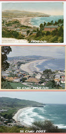
GIS mapping of past shoreline positions
The mapping of past shorelines over the whole length of Ocean Beach will identify the scale to which human interventions have affected shoreline position and shape, such as the influence of the St Clair Seawall, Middle Beach landfill and sports field development activities, and the construction of John Wilson Drive.
Top of this page
Determine landfill rubble locations and extent
This would entail a ground penetrating radar survey of the dune environment at Kettle Park and John Wilson Road to determine the extent of rubble buried under the dune system that may be exposed with future shoreline movements (also see Historical/cultural/social research below).
Wave refraction and sediment transport modelling
This is needed to reduce uncertainty about the nature of the inshore wave climate and the magnitudes and directions of sediment transport in various wave conditions. This information is required for inputs into storm response and long-term plan shape evolution modelling, and for the evaluation of different long-term management options.
Storm response modelling
Storm response modelling will qualify the range of potential responses of the beach and dune environment to storm events. These responses will vary depending on the size and direction of the storm event, and the antecedent beach conditions (eg height and volume). This modelling will include any changes to water levels and wave climate as a result of predicted sea level rise. The output of this type of modelling is required to test the likely success of the various long-term solutions and their likely impacts on the beach under these conditions.
Top of this page
Future shoreline modelling
Future plan shape evolution modelling is required to predict how Ocean Beach may respond in plan shape in the future to the forecasts for wave climate, sediment supply and transport, and sea level rise over the next 50 years. The modelling can include plan shape responses to future management options such as additional seawalls, groynes, beach re-nourishment, and offshore breakwaters.
Analysis of potential sand sources
A number of the possible long-term options will require additional volumes of sand to be placed on the coast or in the near-shore at Ocean Beach for beach re-nourishment. There is a need to investigate risks to adequate supply, including volume, suitability such as grain size, colour and lack of contaminants, transport routes and methods, whether road, pipeline or boat, dumping location such as behind or on the beach, or in near-shore and possible storage options.
Summary report and analysis of data
This will be a report summarising the data collection and modelling. It will present these in the form of a SWOT (Strength, Weakness, Opportunities and Threats) analysis.
Top of this page
Historical/cultural/social research
Research into the historical, cultural and social aspects of Ocean Beach is necessary. It should be carried out as a project to produce a bibliography of historical and cultural information on Ocean Beach, available to the project team responsible for drafting the long-term plan.
This research also satisfies the recommendation from DTec Consulting Limited/Shore Processes and Management Limited for a historical review of documents, files and photos of Ocean Beach Dunes and hinterland including Kettle Park Landfill and Sports Field Development. This allows a more complete understanding of the modification of the Ocean Beach dunes by human intervention and better understanding of the changes that have lead to the current situation.
Ecological assessment
An ecological assessment will be carried out to provide advice on options for appropriate ecological management for the rehabilitation of areas likely to be affected by physical works, re-nourishment programmes and recreational use.